
Thompson Knolls
Significant Potential for a Large Copper-Gold-Silver-Molybdenum Porphyry System
Overview
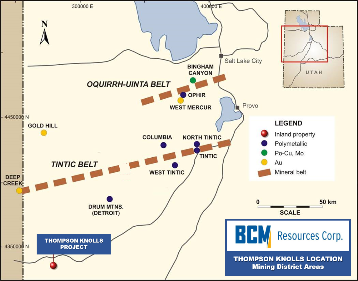 BCM Resources Corp. (“BCM,” the “Company”) owns a 100% interest in its flagship Thompson Knolls Project, a greenfield copper-molybdenum-gold-silver property in central Utah's Great Basin, one of the premier metallogenic provinces in the world (and referred to herein as the “Property”, “TKP”, “Thompson Knolls Property” or “Thompson Knolls”). The Thompson Knolls Property is located in Millard County, Utah, and comprises 225 federal unpatented lode mining claims and two state section leases, totaling 5,540 acres (2,242 ha).
Thompson Knolls is located on the west side of the Confusion Range, south of Highway US-6/US-50. BCM has divided the area into two main targets, Thompson Knoll (“TK”) on the north, and Discovery Knoll (“DK”) to the south. BCM is pursuing porphyry copper (“PCD”) targets on the Property. A prominent magnetic “high” anomaly at TK was found in a U.S. Geological Survey aeromagnetic survey in 1972, which led to the later formulation of a PCD model for this target area.
The Confusion Range is known for numerous outcropping gold-bearing jasperoids, including at the King’s Canyon gold deposit to the northeast of Thompson Knolls, where approximately 217,000 ounces of Carlin-style gold at a grade of 0.03 ounces per tonne gold (Zimmerman, 2009) were drilled out in 1990 to 1993 by Crown Resources. Other mineralized areas in the vicinity include 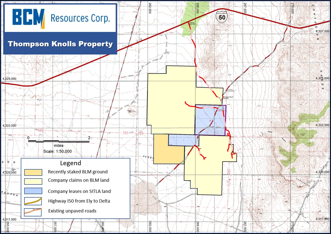 the mineral prospects of Silver Dream, Road Canyon (Echo Bay drilling), and Boob's Canyon, all located to the southeast of Thompson Knolls. The Property has excellent access to infrastructure and is located approximately 35 km east of the town of Baker, Nevada, and 1.7 km south of Highway US-50/US-6. It is approximately 4 km southwest of the King’s Canyon gold deposit.
Historic shallow rotary RC drilling was conducted at Thompson Knolls in both target areas between 1991 and 1996 by Crown Resources and Centurion Mines Corp., who drilled several drillholes in locally altered middle Paleozoic carbonate rocks (one hole at TK, and another hole at DK) that intersected encouraging high-grade copper-gold-silver mineralization which assayed 9.15 metres of 8.01 grams per tonne gold (0.234 oz/t Au*) and 6.09 metres of 0.28% copper. This copper mineralization could be related to a porphyry copper system on the TKP. Local disseminated low-grade Carlin-style gold mineralization was found in other Centurion drillholes at DK.
* These assay results are from historic drilling and are presented for information only. These results from hole CKC-96-10 cannot be relied upon, as original assay data sheets from a recognized third-party analytical laboratory have not been confirmed by a Qualified Person.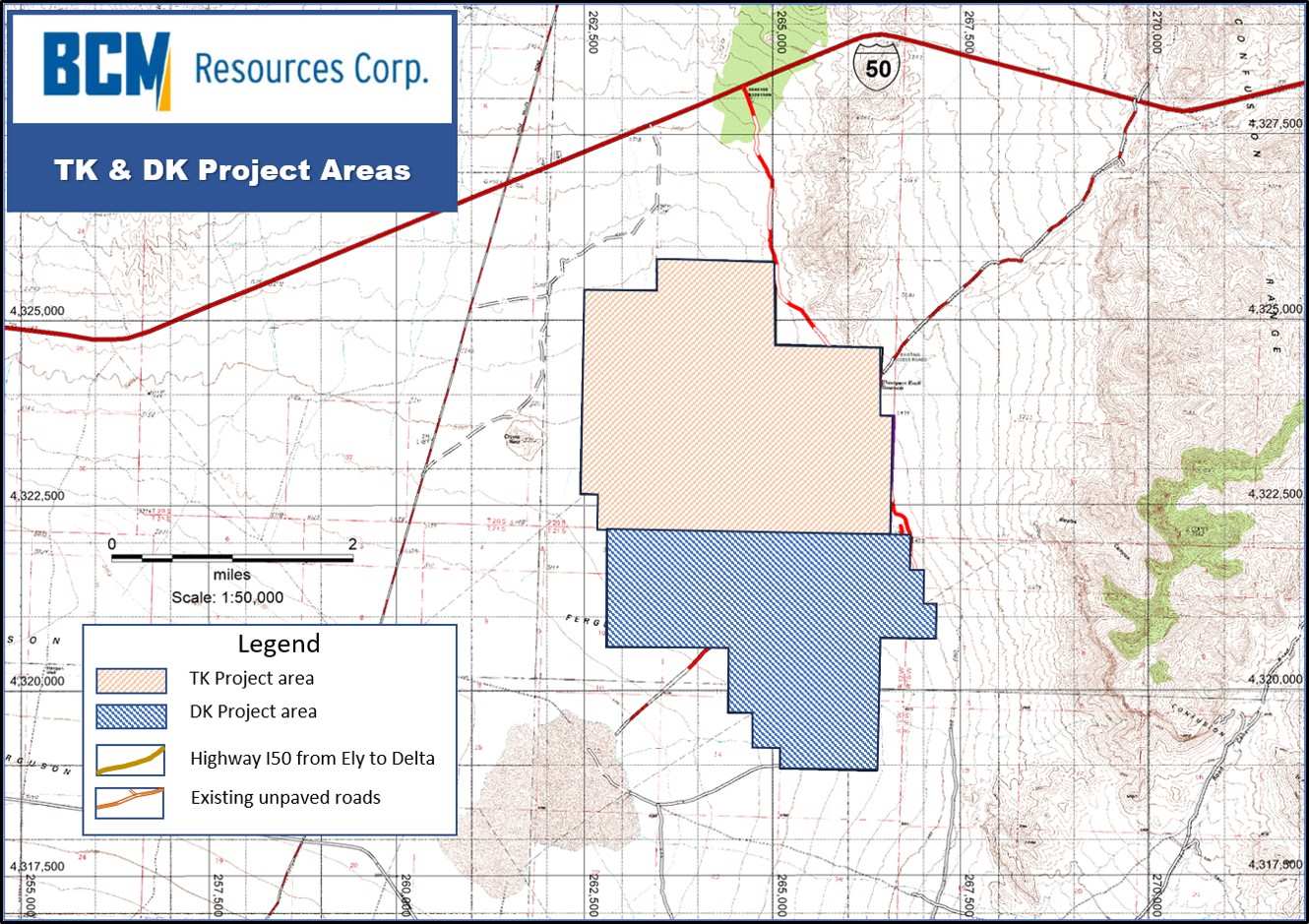
Favorable Features
Mineralized structures at the King’s Canyon gold resource locally trend SW towards the Thompson Knolls area, while structures at Boob's Canyon, Silver Dream, and Road Canyon trend NW into the Discovery Knoll area. Most of the known mineralization in the Confusion Range consists almost exclusively of disseminated pluton-centric Carlin-style low-grade gold, but mineral occurrences on the west side of the range at Boob's Canyon and the Silver Dream locally include high-grade silver and are younger than the inferred porphyry copper-gold mineralization, possibly of Miocene age.
Work Overview
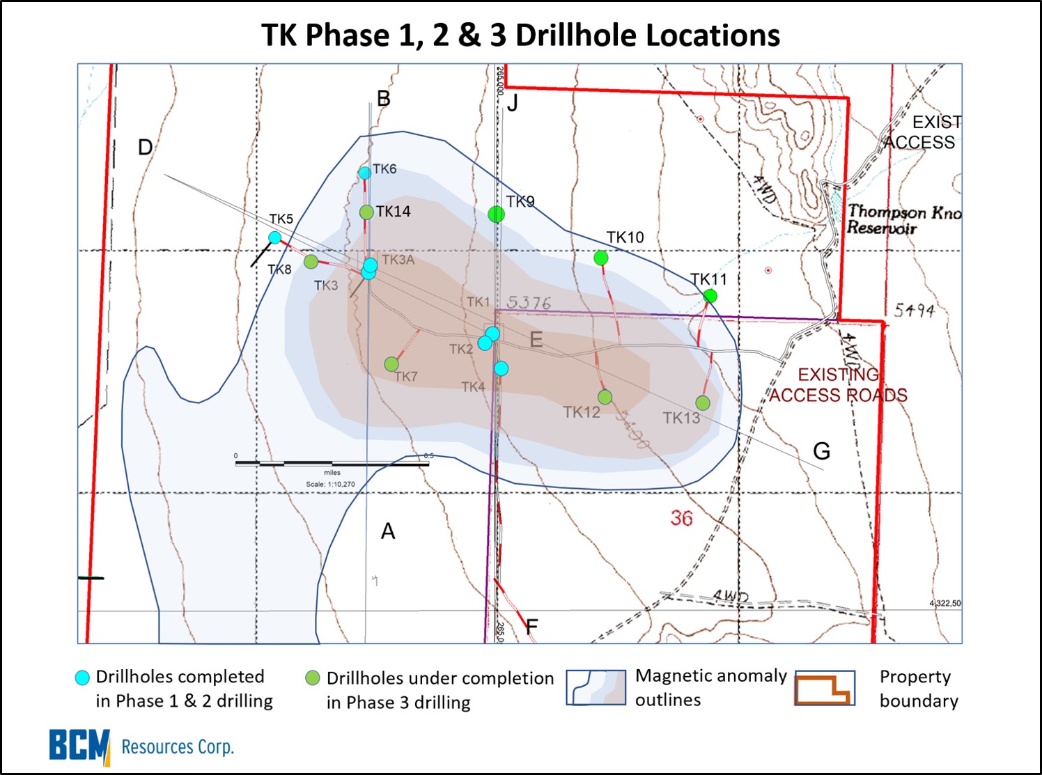 Work to date has consisted of historic mapping, sampling, ground magnetics, and IP surveys. More recent gravity, drone magnetics, and AMT surveys were completed by BCM. A total of 10 core holes have been completed at TK to date, (including 7 holes completed in Phases 1 & 2). Phase 3 core drilling in the TK target area commenced in October, 2022 and the program is ongoing.
Approved Plan of Operations – Expanded Program
In July, 2023, the Company received approval from the Bureau of Land Management (“BLM’) for a Plan of Operations (the “PoO”) to conduct a significantly larger ongoing exploration program . Good for ten years, the PoO allows for expanded drilling over the entire TKP, with up to 10.5 acres (4.25 ha) open at a time and a total allowed disturbed ground of 20 acres (8.1 ha) for the duration of PoO. Approval of the PoO is an important Milestone and the Company will now be able to conduct exploration drilling with multiple drilling rigs working simultaneously. This will significantly increase the speed of drill testing of all outlined targets within TKP boundaries.
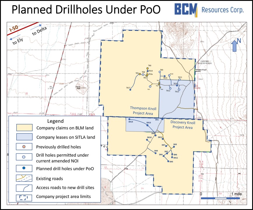 The Company’s initial program under the PoO will includes a fourth phase of drilling at TK (“TK 4”) and an initial two phases of drilling at DK (“DK1” & “DK2”) and includes 17 additional drill sites at both TK and DK projects with approximately 51,000 ft (15,545 m) anticipated drilling. Currently disturbed ground at TKP amounts to approximately 4.7 acres (1.9 ha) of which about 50% of the previously disturbed ground is in the reseeding/reclamation process.
Now, with the PoO approved, the Company is authorized for up to an additional 5.8 acres (2.35 ha) of ground disturbance, totaling 10.5 acres (4.25 ha) at any given time.
A Phase 4 drill program at the TK project envisages the drilling of additional drill holes in the northwestern extension of mineralization intercepted in drill holes TK3a, TK8, TK14, and TK6.
In addition, “B” is planning to begin Phase 1 and Phase 2 drill programs in the southern portion of the Property at the DK project. Phase 1 & 2 drilling at the DK project will test the southern portion of TKP for evidence of the porphyry system. Historical shallow RC drilling intercepted gold-copper mineralization at DK that assayed 9.15 meters of 0.234 oz/t (8.01 g/t) Au and 6.09 meters of 0.28% Cu, which may represent a separate porphyry system or an extension of the TK porphyry to the south.